Luxeuil-les-Bains
Directions / From Paris / From town center / Detailed map
This page explains how to get to the fine village of Luxeuil-les-Bains. This depends on your starting point, and there are a number of ways to reach this village depending on this.
Directions
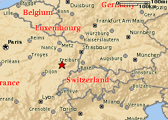
Here are the directions to the village of Luxeuil-les-Bains assuming you are starting at Paris, France (see table below).
If you are heading down from the north, eg. from Holland or Belgium, then travel to Metz. From there follow directions to Nancy, turning off on the N57 to Epinal. Keep going towards Plombieres-les-Bains.
From the south follow Lyon and then further up north towards Dijon.
 The red star marks Luxeuil-les-Bains. All maps are courtesy of mapquest. |
From Paris
These are the directions from Paris to Luxeuil-les-Bains.
| Time | Km | Instruction | For | Towards |
|---|---|---|---|---|
| 09:00 | 0.0 | Depart Paris on Rue de Rivoli (North-West) | 80 m | |
| 09:00 | 0.1 | Turn LEFT (South) onto Local road(s) | 0.2 km | |
| 09:01 | 0.3 | Turn LEFT (East) onto Quai de l'Hôtel de Ville | 1.2 km | |
| 09:03 | 1.5 | Bear RIGHT (South-East) onto Quai Henry IV | 0.7 km | |
| 09:05 | 2.1 | Bear RIGHT (South) onto Local road(s) | 0.7 km | |
| 09:06 | 2.8 | Bear RIGHT (South-East) onto Quai de la Rapée | 0.7 km | |
| 09:08 | 3.5 | Continue (South-East) on Quai de Bercy | 1.9 km | |
| 09:11 | 5.4 | At Porte de Bercy, turn RIGHT (South-East) onto A4 [E50] | 4.2 km | Reims |
| 09:14 | 9.6 | At A4-A86, turn RIGHT (South) onto A86 | 5.0 km | |
| 09:17 | 14.6 | At A86-N6, continue (South) on N6 | 18.3 km | |
| 09:31 | 32.9 | At 26, turn RIGHT (South) onto N104 | 1.0 km | |
| 09:32 | 33.9 | Toll Road Turn LEFT (South-East) onto A5a | 9.5 km | |
| 09:38 | 43.4 | Toll Road Continue (East) on A5 | 226.7 km | Troyes |
| 11:55 | 270.1 | Toll Road At A5-A31, turn LEFT (East) onto A31 [E21], [E54] | 24.1 km | Nancy |
| 12:10 | 294.2 | At 8 Bourbonne-les-Bains/Montigny-le-Roi, bear RIGHT (East) onto D417 | 65.6 km | Bourbonne-les-Bains |
| 13:11 | 359.8 | At Saint-Loup-sur-Semouse, bear LEFT (East) onto D83 | 2.2 km | |
| 13:14 | 362.0 | Bear RIGHT (South-East) onto D64 | 10.0 km | Luxeuil-les-Bains |
| 13:24 | 371.9 | Arrive Luxeuil-les-Bains |
| SUMMARY: | |
| Total distance: | 371.9 kilometers |
| Driving time: | 4 hours, 24 minutes |
From town center
Once you have made it to the town Luxeuil-les-Bains, here are the last few steps to the final resting place of Kiffin Yates Rockwell. Let's assume that you are starting from the Tourist Information:
- Stand in front of the entrance to the Office de Tourisme facing the street on the corner of Avenue des Thermes and Rue Carnot.
- Turn to the left and cross the Rue Carnot. Immediately a couple meters to the right, you will see a small alleyway between the houses called Rue Sainte Anne. Follow this street up the hill winding slightly to the left.
- After about 100 meters you will see a parking lot and on the other side the high stone walls of the cemetery.
- Turn to the right and follow the walls and you will eventually reach the entrance way at the end, two very large black iron gates. A sign to the left will say Common Wealth War Cemetery. Please enter.
- On the very first row of gravesides, turn left and walk up the gravel path. On your right will be the start of the white war veteran tombstones. About halfway you will see the famous bronze plaque and at last you will have found Kiffin Yates Rockwell's final resting place.
Detailed map
The detailed map of Luxeuil-les-Bains below should hopefully provide you with enough detail. The red star in the Cimetiere marks the spot where Kiffin is buried. I recommend that you stay at the Hotel Beau Site, the nicest (three star) hotel in the area. Also check out the Cloister on the Place de l'Abbaye where some relic is preserved (I think it is a piece of the cross, if I remember correctly).

nice post... :)
">dormire a parigi